 Intranet


Vulnérabilité des aquifères au Vietnam
Evaluation of shallow aquifer resources and vulnerabilities using geophysical electrical methods in the South of Vietnam
Description du projet :
Groundwater uptakes for HCM City needs (30% of the domestic water) as well as agriculture needs in the Saigon River basin and the Mekong delta rely on shallow (0-100m) and deeper (100-300m) aquifers that are thought to be separated by inter-stratifying clay layers with no evidence of their continuity, creating a possible vulnerability to pollutants. Information is therefore required on aquifer geometry and lithology (top and bottom of aquifer including thickness and extent of hydrostratigraphic unit). Moreover, there is no available information about the contribution of the potentially polluted top aquifer to the Saigon River. Close to the sea in the Mekong delta, saline intrusion occurs. In addition, at east of HCM province (hard rock), the acquifer system is poorly documented : lack of knowledge about storativity /geometry/ implementation of boreholes (success rate ?)…
These knowledge gaps reflect a lack of comprehensive information on groundwater resources and related recharge processes. In particular, the question raise : what are the hazards related to the main recharge zones ? : are they vulnerable to pollution ?, and how are river-aquifer and aquifer-aquifer relationships affecting water resource vulnerability ?
Therefore the aim of the PhD project is to contribute to the aquifer knowledge by the application of integrated resistivity methods (time and frequency domain electromagnetic soundings, electrical resistivity tomography) (and Magnetic Resonance sounding (MRS) ?) for shallow aquifer characterization in the South of Vietnam.
For IRD and IJL –LMI “Le CARE”, the outputs of this PhD will be a) a core contribution to the work-package “Groundwater vulnerabilities” with a focus on geophysical methodology that can be applied for maps of clay layers at several scales and b) a key project to contribute to the building of a new hydrogeophysical team based at the “GEOPET” faculty (geology).
Méthodologie
Because the geology of the area (Saigon River basin and Mekong delta) is composed of an alternation of sand, loamy and clay deposits, and because clayey layers play a significant role in groundwater flux processes, the PhD will be primarily based on the study of a key parameter, the electrical resistivity of the soil. As shallow aquifers are targeted (due to their ability in providing fresh water at a lower cost than deep aquifers) several methods measuring resistivity at different depths will be used to define the aquifer dimensions : Time Domain Electromagnetic Soundings (TDEM), Electrical Resistivity Tomography (ERT), Frequency Domain profiling (FDEM). In addition ; Magnetic Resonance Sounding (MRS) could be also considered. The study adopted these methods with special emphasis on defining the lateral and depth extent of freshwater aquifer, and to define relative variations in water quality and the presence of clay units within the sand aquifers.
Those methods will be applied to investigate the recharge conditions and vulnerability of shallow aquifers in agricultural and industrial landscapes North of Ho Chi Minh City. This area is already identified as shown in the Figure.
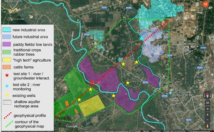
Additional sites are identified in Mekong Delta, in Ben Tre province for saline intrusions studies.
Several pollutions sources (not yet ascertained) are identified. The main objective of the study is to verify and/or evaluate the effectiveness and reliability of geophysical methods as a contributor to groundwater investigation/quantification in the Cu chi area with available hydrogeological data. The data acquired will be compared with ground truth data (hydrogeological boreholes) that is currently available or that will be collected during the fieldwork.
Objectifs spécifiques
- To make a comprehensive evaluation of available hydrogeological data such as wellbore data (lithological logs), grain size analysis, geophysical logs
- To assess if the TDEM/FEM soundings provide reliable information on aquifer boundaries (aquifer geometry), groundwater table, effective porosity and eventually the applicability of the technique in the other areas of the country with similar geology.
- Beside, the combination with MRS can detect storage parameters and estimates of flow parameters (hydraulic conductivity K, permeability ki and transmissivity T).